Licensing

Rent the SkyShield GCS licence.

One licence, per device, per month — and it has everything you need in it. No editions to compare, nothing to add on later, and nothing held back for a higher tier.

What you're renting

The whole station, screen by screen.

Real captures from the software you would be running: planning, flight, payload and the AI analytics. Not a rental build — the same station we fly ourselves.
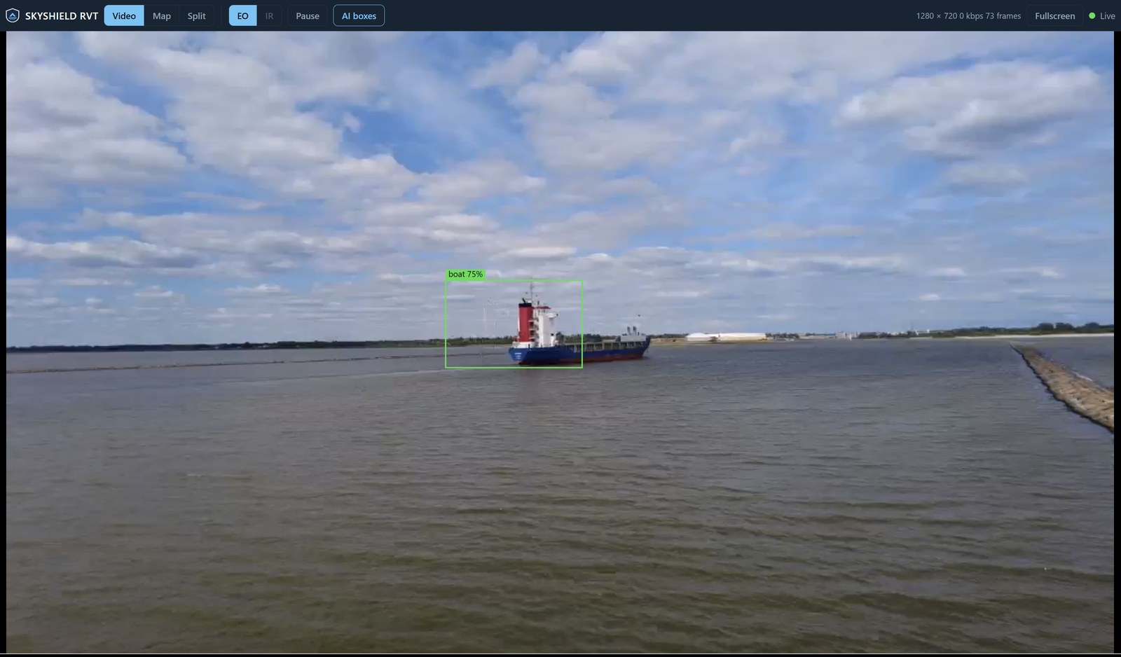
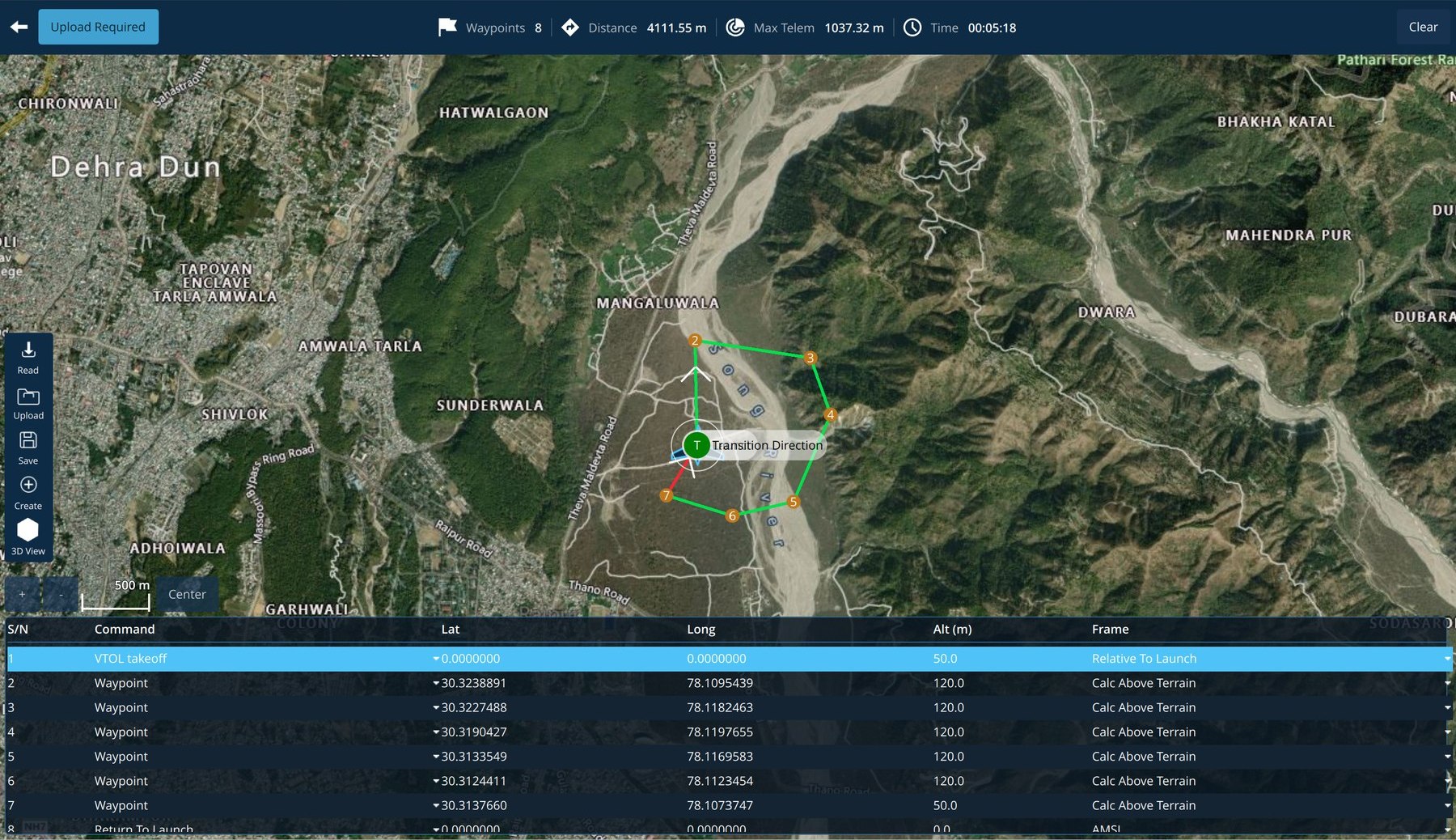
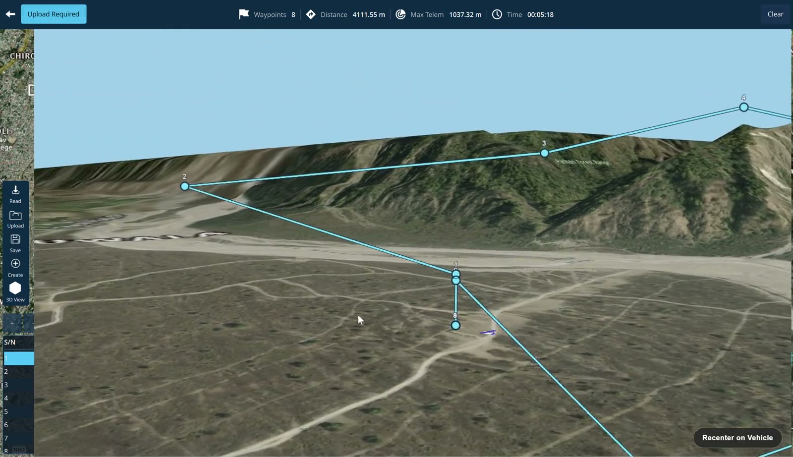
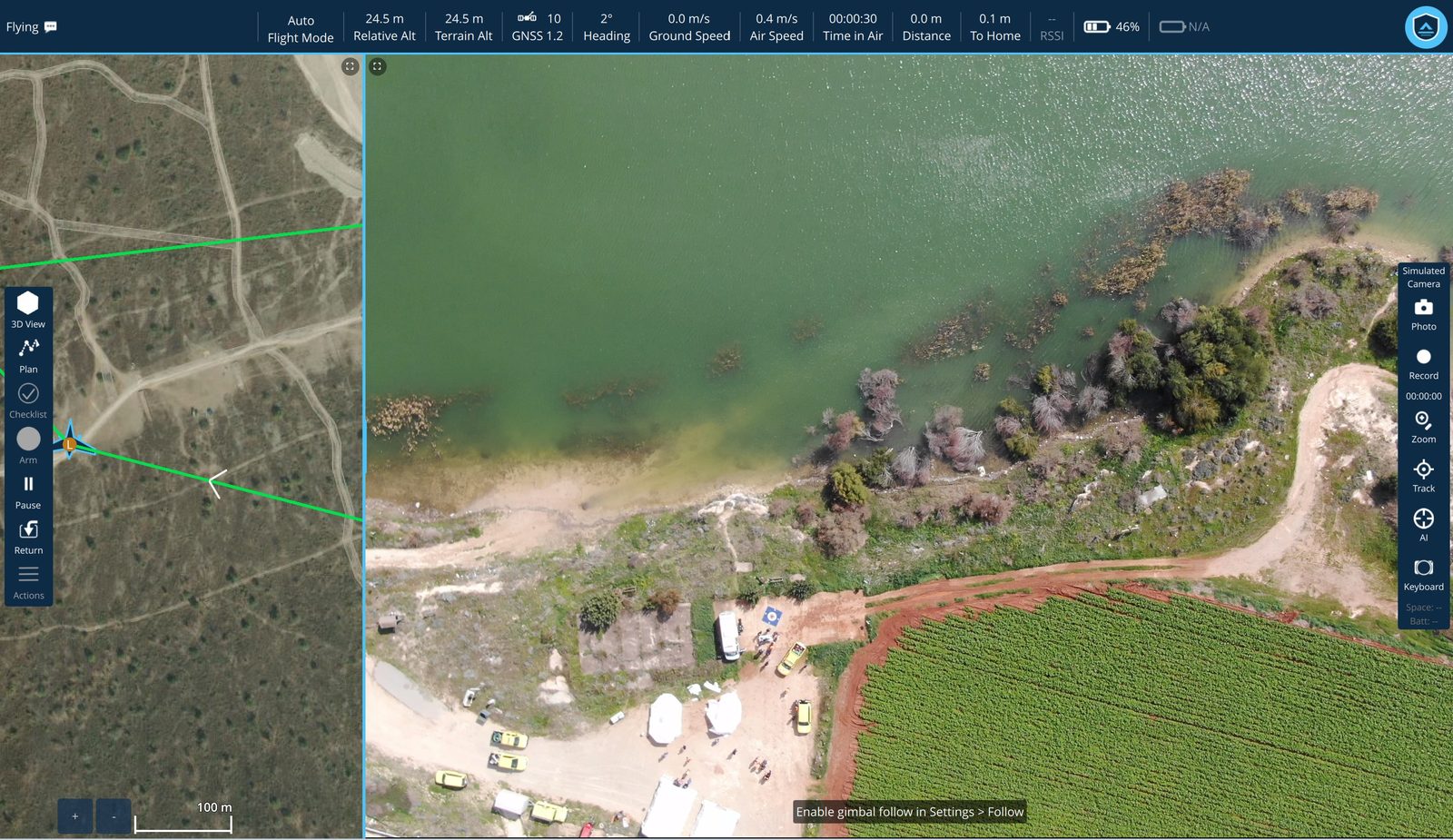
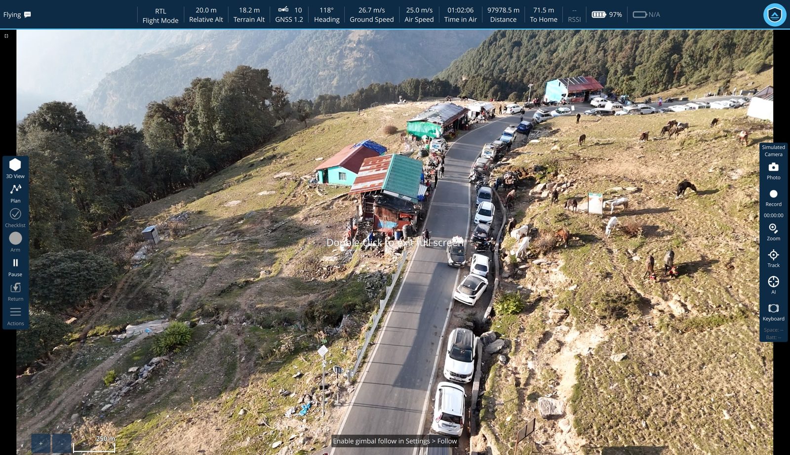
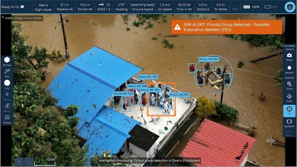
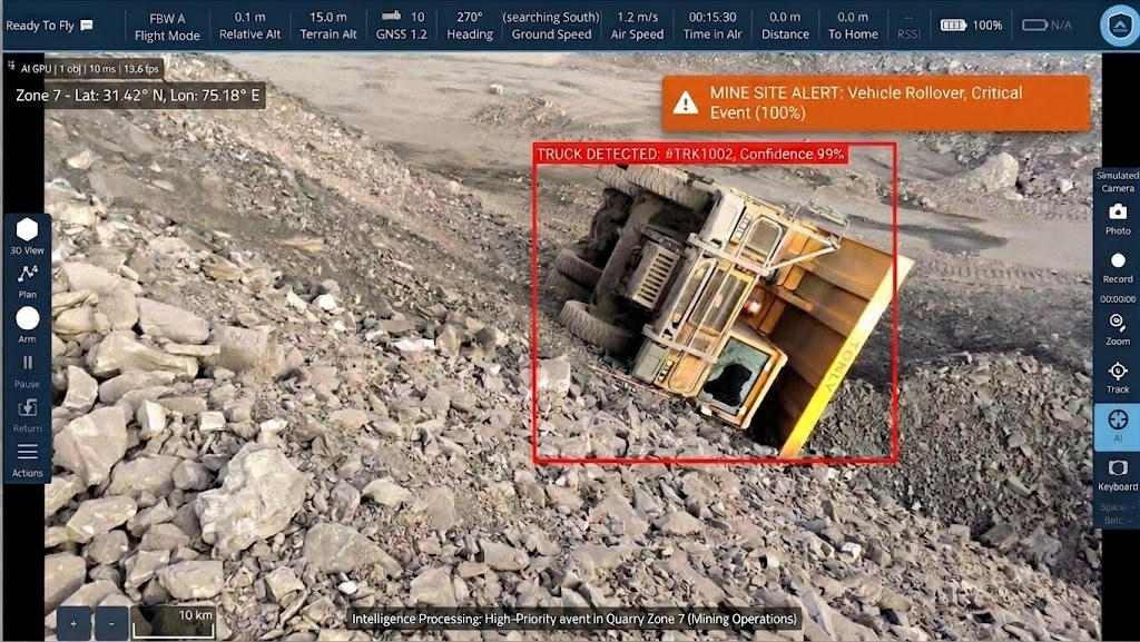
The Remote Video Terminal open in a plain browser: a control bar with Video, Map and Split views, EO and IR camera sources, Pause and an AI boxes toggle, a green Live indicator and the stream size, over sharp aerial video of a cargo ship on a wide estuary with a green detection box labelled boat 75 percent drawn around it. Plan View: an eight-waypoint mission drawn over satellite terrain with a VTOL transition marker, and an editable mission table below listing sequence, command, latitude, longitude, altitude and altitude frame for every item. The ground station's 3D view, a planned route drawn as a chain of waypoints over real mountain terrain with leg distances and maximum terrain height shown along the top. Fly View: satellite map with the flight path on the left, live aerial video of a shoreline and field on the right showing vehicles and people on the ground, telemetry across the top. The station in full-screen video over a mountain road, cars and pack animals visible along the route, with only the telemetry bar and camera toolbar over the picture — no floating panels, no analytics overlay. The ground station running detection on a flooded neighbourhood: twenty-three objects tracked, a cluster of people on a rooftop each boxed and numbered with confidences from 88 to 98 percent, a group ring drawn around a second cluster, and an amber SAR alert reading 'Priority Group Detected — Possible Evacuation Needed (95%)'. A status line reads 'Intelligence Processing: Critical group detection in Zone 4 (Floodplain)'. The ground station running detection at a rock quarry: a haul truck on its side boxed in red and labelled 'TRUCK DETECTED: #TRK1002, Confidence 99%', with an orange alert reading 'MINE SITE ALERT: Vehicle Rollover, Critical Event (100%)' and the zone's GPS coordinates shown. A status line reads 'Intelligence Processing: High-Priority event in Quarry Zone 7 (Mining Operations)'.
Remote video terminal Watched from a phone, in a browser Live video, AI boxes and alerts, served by the station itself
Plan view Plan the mission, then edit it as a table Waypoints over satellite terrain, VTOL transition marked
3D view Walk the route over real elevation Leg distances and maximum terrain height along the top
Fly view Map and live feed, side by side Flight path, telemetry and the camera in one window
Video window The feed, and nothing else Full frame, with only the telemetry bar and camera toolbar over it
AI analytics Detection running on the live feed People on a rooftop, boxed and counted, the alert raised on its own
AI analytics Incidents graded and raised A haul truck on its side, flagged the moment it appeared

The terms

Rent the capability, not the capital.

Per device

Priced by the month

Against the machines you actually fly from, so a season's work costs a season rather than a purchase order.

No tiers

Everything unlocked

The full station from the first day — nothing reserved for an edition above yours.

While it runs

Updates included

You fly what we ship, not the build you happened to license.

Direct

Support from the makers

Dehradun, the people who wrote it — not a ticket queue.

Everything in the licence

One plan. Every module unlocked.

Planning through to post-flight analysis, on every licence we issue. The rental is not a reduced build.

Mission
  • Fly View — map and video
  • Plan View — waypoint planning
  • Editable mission table
  • 3D terrain mission review
  • Terrain / AMSL / relative frames
  • Vertical takeoff, loiter, return
  • Geofence and boundary limits
  • Pre-flight checklist
Vehicle setup
  • Airframe configuration
  • Radio / RC calibration
  • Flight mode assignment
  • Compass and accelerometer calibration
  • Level horizon alignment
  • Power and battery setup
  • Motor test and ordering
  • Safety and failsafe rules
  • Camera and gimbal setup
Video & payload
  • Network video — RTSP, UDP, TCP
  • Local file playback
  • Thermal picture-in-picture
  • Thermal full-frame
  • Thermal blended, adjustable opacity
  • Laser rangefinder distance
  • Photo and video recording
  • Zoom and click-to-track
Remote video terminal
  • Live video to any browser
  • Nothing to install to watch
  • Viewers join by QR code
  • Station can host its own Wi-Fi
  • Map and AI boxes travel with it
  • Alerts and telemetry on the page
  • Viewer limit and page port
AI analytics
  • GPU object detection
  • Multi-object tracking
  • Distinct-object counting
  • Model and confidence control
  • Model-free visual tracker
  • Situational-awareness review
  • Graded incident alerts
Comms
  • Serial telemetry
  • TCP and UDP links
  • Bluetooth
  • Multi-link with failover
  • Telemetry logging
  • Remote ID
  • ADS-B traffic display
Analysis
  • On-board log download
  • Flight log replay
  • MAVLink inspector
  • MAVLink console
  • Vibration analysis
  • Image geotagging
  • Spoken status callouts

Connect

Tell us the fleet. We'll send the number.

Pricing follows device count and term, so we quote it rather than print a figure that fits nobody. Send the fleet size and the work it's for, and a number comes back.